$27 Billion to $40 Billion in Insured and Uninsured Losses from Hurricane Ida, CoreLogic Estimates

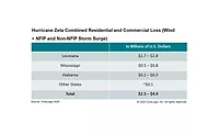
CoreLogic, a leading global property information, analytics and data-enabled solutions provider, announced residential and commercial wind, storm surge and inland flooding loss estimates for Hurricane Ida. According to this new data analysis, insured and uninsured losses from wind, storm surge and inland flooding damages to residential and commercial properties in Louisiana, Mississippi and Alabama are estimated to be between $27 billion and $40 billion.
Total insured flood loss for residential and commercial properties in Louisiana, Mississippi, and Alabama is estimated to be between $6 billion and $9 billion, which includes both storm surge and inland flooding. Uninsured flood loss for this area is estimated to be between $8 billion and $12 billion. Insured wind losses are an estimated additional $8 billion to $12 billion. More than 90% of the losses are estimated to be in Louisiana, primarily in the nine parishes in the New Orleans-Metairie-Hammond metropolitan area and in the Ascension, Lafourche, Livingston and Terrebonne parishes immediately to the west.
Hurricane Ida, the fourth hurricane and second major hurricane of 2021, rapidly intensified into a Category 4 hurricane before making landfall near Port Fourchon on Sunday, August 29, the 16th anniversary of Hurricane Katrina. Much of Louisiana’s housing stock was spared from the worst of the initial landfall, as Port Fourchon is a remote area approximately 15 miles southwest of Grand Isle and is known for its significant transport of petroleum. In areas near Hurricane Ida’s landfall, destructive winds exceeded 145mph. Substantial damage to property from wind and flooding occurred in the days immediately following the storm.
“Hurricane Ida made landfall less than 40 miles away from where Hurricane Katrina made landfall, but the two storms had substantially different characteristics,” said Tom Larsen, principal, insurance solutions at CoreLogic. “Even though Hurricane Ida was a higher wind-speed Category storm at landfall, Hurricane Katrina had a much larger wind field and had spent many hours as a Category 5 hurricane before weakening during its approach to landfall. It brought much higher storm surge than Hurricane Ida and flooded 80% of New Orleans in addition to devastating the Mississippi coast. With climate change affecting the ocean’s temperatures, we should expect to see more frequent and destructive tropical cyclone activity. Homeowners and regional public agency leaders should prepare for more resilient city infrastructure and financial protection from catastrophe.”
“While only 40 to 50% of the flood damages from Hurricane Ida appear to be covered by insurance, this is actually an improvement from the uninsured flood damages we saw from Hurricanes Harvey and Katrina,” Larsen said. “The flood insurance gap is shrinking.”
This analysis includes residential homes and commercial properties, including contents and business interruption and does not include broader economic loss from the storm. The inland flood analysis is based on the rainfall for 48 hours ending at 6 a.m. CDT on August 31.
CoreLogic is a leading global property information, analytics and data-enabled solutions provider. The company’s combined data from public, contributory and proprietary sources includes over 4.5 billion records spanning more than 50 years, providing detailed coverage of property, mortgages and other encumbrances, consumer credit, tenancy, location, hazard risk and related performance information. The markets CoreLogic serves include real estate and mortgage finance, insurance, capital markets, and the public sector. CoreLogic delivers value to clients through unique data, analytics, workflow technology, advisory and managed services. Clients rely on CoreLogic to help identify and manage growth opportunities, improve performance and mitigate risk. Headquartered in Irvine, Calif., CoreLogic operates in North America, Western Europe and Asia Pacific.
Methodology
CoreLogic offers high-resolution location information solutions with a view of hazard and vulnerability consistent with the latest science for more realistic risk differentiation. The high-resolution storm surge modeling using 10m digital elevation model (DEM) and parcel-based geocoding precision from PxPoint™ facilitates this realistic view of risk. Single-family residential structures less than four stories, including mobile homes, duplexes, manufactured homes and cabins (among other non-traditional home types) are included in this analysis. Multifamily residences are also included. This is not an indication that there will be no damage to other types of structures, as there may be associated wind or debris damage and are not tabulated in this release.
Source: CoreLogic
Looking for a reprint of this article?
From high-res PDFs to custom plaques, order your copy today!


