2026 Hurricane Forecast Shows Fewer Storms but Greater Risk
Learn why lower storm count can still produce major losses for restorers
Hurricane season is right around the corner, and the early forecasts deliver a message that is counterintuitive. Fewer storms named doesn’t mean lower risk, but potentially greater risk.
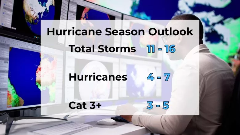
AccuWeather’s 2026 Atlantic outlook projects 11–16 named storms, with approximately 3–5 expected to directly impact the United States. This year’s total falls below the long-term average and at first glance suggests a quieter season; however, meteorologists and federal forecasters caution against equating storm count with impact. Historically, storm behavior, rather than storm volume, has proven to be the driver of damage and recovery demand¹.
Why a “Below-Average” Season Can Still Be Dangerous
El Niño serves as one of the primary drivers for this year’s hurricane season as it typically suppresses hurricane formation because of its increased wind shear across the Atlantic. However, research and historical trends show that El Niño years can produce stronger hurricanes when the environmental conditions align just right².
The National Hurricane Center (NHC) has made one thing very clear: even just one major hurricane can define an entire season for the year, regardless of forecasted totals. NOAA noted in multiple post-season analyses, communities only need to experience one storm to make landfall to feel the full economic and human consequences of hurricane season³.
For our industry, this distinction is critical. A lower storm count can lead to complacency; however, now is not the time. The potential for high-impact hurricanes still remains elevated.
Critical Forecast Updates for the 2026 Season
One of the most significant updates for this year is the NOAA’s decision to expand their hurricane forecast cone to reflect inland tropical storm and hurricane impacts⁴. This change highlights what recent seasons have already shown us: hurricane damage does not stop at the coastline. In fact, it can extend far beyond that.
The 2024 season showed how inland states can experience catastrophic wind, rainfall, flooding, and long-term displacement. According to the NOAA and post-season damage assessments, some inland regions faced recovery timelines measured in years, not months⁵.
Looking for quick answers on restoration, remediation and cleaning topics?
Try Ask R&R, our new smart AI search tool.
Ask R&R →
One thing is clear: coastal wind is no longer the sole first-loss trigger; inland wind, rainfall, and flooding are now primary hurricane-related damage drivers.
Saharan Air Layer, Natures Suppressant
Last year, the Saharan Air Layer (SAL) limited early-season activity through its dry air, dust, and increased wind shear, but one thing it didn’t eliminate was the storms that formed after the SAL lifted. We generally see peak “season” for SAL between June and mid-August, and once it lifts, historically we’ve seen strong, hard-hitting storms and hurricanes form shortly after. The important thing to remember here is, yes, it can suppress the activity, but it doesn’t eliminate the risk.
If we take a quick look at the major Atlantic hurricanes over the last decade, the data shows a consistent trend: some of the most destructive storms formed after peak SAL season, often between late August and October. The NOAA and AccuWeather have both documented that once this layer weakens, tropical activity can ramp up quickly with little to no warning⁶ .
The key takeaway is not that suppression equals safety, but delayed seasons often compress risk into shorter, more volatile periods.
Forecast Accuracy vs. Impact Reality
The NOAA’s verification data shows that seasonal storm-count forecasting has improved over the last five years; however, there are a few significant uncertainties we can’t ignore:
- Rapid intensification
- Rainfall totals
- Storm stalling
- Inland track deviations
According to NHC forecast verification reports, intensity and track error during rapid strengthening phases remain major challenges, even in well-modeled seasons⁷. These uncertainty windows are often where the most severe losses occur.
This gap explains why preparedness cannot take a back seat with seasonal outlooks alone.
What This Means for the Restoration Industry
From the early forecasts and predictions, this year’s outlook reinforces several operational realities:
- Hurricane risk is no longer strictly coastal
- Fewer storms can still generate higher cumulative losses
- Inland readiness is now operationally mandatory
Hurricane-related restoration demand stems from rain-driven flooding, prolonged moisture exposure, power outages, and contamination risks rather than peak wind speeds⁸.
As the season continues to evolve and affect planning, staging, documentation, and strategy, you as restorers shouldn’t just rely on traditional coast mobilization.
Risk Has Shifted, Not Declined
Although the forecast points to fewer storms, the NOAA and industry data make one thing very clear:
- Hurricane risk has not decreased. It’s become more concentrated, and less predictable
Our success this year depends less on storm chasing and more on disciplined preparedness, positioning, and technical execution. Whether the season delivers one catastrophic hurricane or several, the impact, not the storm count, will define the season.
When hurricane behavior sets the tone, there is no such thing as a “quiet” season.
Resources:
-
AccuWeather. 2026 Atlantic Hurricane Forecast: 11–16 Named Storms Predicted.
https://www.accuweather.com/en/hurricane/atlantic-hurricane-season-forecast-2026-11-16-named-storms-predicted-by-accuweather/1875776 -
NOAA Climate Prediction Center. El Niño Outlook and Impacts on Atlantic Hurricane Activity.
https://www.yahoo.com/news/articles/atlantic-hurricane-season-forecast-2026-102440673.html -
NOAA National Hurricane Center (NHC). Tropical Cyclone Reports by Season.
https://www.nhc.noaa.gov/data/tcr/ -
NOAA / National Hurricane Center. Expanded Hurricane Forecast Cone for Inland Impacts (2026).
https://cbs12.com/weather/hurricane-stories/tracking-the-tropics-national-hurricane-center-nhc-unveils-new-forecast-cone-for-2026-hurricane-season-florida-storm-tropical-storm -
NOAA Climate.gov. 2024 Billion-Dollar Weather and Climate Disasters Review.
https://www.climate.gov/news-features/blogs/beyond-data/2024-active-year-us-billion-dollar-weather-and-climate-disasters -
AccuWeather. Massive Saharan Dust Clouds to Approach Florida Gulf.
https://www.accuweather.com/en/hurricane/massive-saharan-dust-clouds-to-approach-florida-gulf/1779232 -
NOAA National Hurricane Center. Forecast Verification Reports (5-Year Review).
https://www.nhc.noaa.gov/verification/verify4.shtml -
NOAA National Centers for Environmental Information (NCEI). U.S. Billion-Dollar Weather and Climate Disasters Database.
https://www.ncei.noaa.gov/access/billions/
Looking for a reprint of this article?
From high-res PDFs to custom plaques, order your copy today!


